As Hurricane Erin continues to intensify in the Atlantic Ocean, the eastern seaboard is feeling the impact—not from wind or rain, but from the massive ocean swells and dangerous rip currents sweeping across beaches from Florida to Massachusetts.
Though the Category 1 hurricane remains well offshore, its far-reaching effects are already prompting beach closures, lifeguard alerts, and marine warnings in dozens of coastal counties.
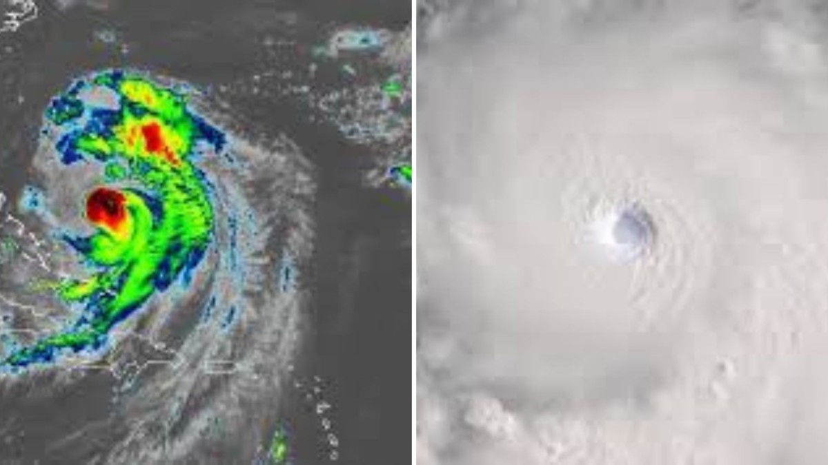
🌀 Hurricane Erin: A “Surf-Generating Machine”
Erin, currently packing sustained winds of 85 mph, is located over 500 miles off the coast but is producing long-period swells that are now reaching East Coast beaches. The National Hurricane Center (NHC) says these swells are increasing in size and energy, pushing waves between 8 to 12 feet in some surf zones and creating widespread, life-threatening rip currents.
“This is classic ‘distant hurricane’ surf—beautiful but extremely dangerous,” said Dr. Leslie Grant, a senior oceanographer at the NHC. “The storm’s energy radiates outwards, generating swells that hit beaches hundreds of miles away.”
🚨 East Coast on Alert: Red Flags Flying at Beaches
Local authorities have raised red and double red flags at popular beach destinations including:
- Daytona Beach, Florida
- Myrtle Beach, South Carolina
- Virginia Beach, Virginia
- Outer Banks, North Carolina
- Cape May, New Jersey
- Montauk, New York
Lifeguards are on high alert, many reporting multiple rip current rescues over the past 24 hours. Emergency services in South Carolina and Florida have urged tourists and residents not to enter the water, regardless of weather conditions appearing calm.
“We’ve already pulled six people from the surf today,” said Chief Lifeguard Daniel Rios of Wrightsville Beach, NC. “The water doesn’t look dangerous, but once you’re in, it’s too late.”
🏄♂️ Surfers Flock to the Coast—Despite Warnings
While swimmers are being urged to stay out, professional and experienced surfers are hitting the water, drawn by the rare and powerful waves generated by Erin.
“It’s the best swell we’ve had in two years,” said pro surfer Mia Lopez, seen paddling out at New Smyrna Beach, FL. “But it’s for advanced riders only. This isn’t the time for weekend warriors.”
Several surf competitions have been postponed or modified due to unpredictable sets and riptide patterns.
⛑️ What Makes Rip Currents So Dangerous?
Rip currents are fast-moving channels of water that pull away from shore, typically forming near sandbars, piers, or jetties. Erin’s distant force is strengthening these currents, turning even waist-deep water into a serious threat.
Signs of a rip current include:
- Water moving rapidly away from shore
- Gaps in breaking waves
- Discolored, foamy, or choppy water in a narrow path
If caught in one, don’t swim against the current. Instead, swim parallel to the shore until you’re out of the current, then swim back at an angle.
🌐 Travel, Tourism, and Local Impact
Hotels along the coast are now alerting guests of the conditions, with some local beaches enforcing full closures through the weekend. Maritime operators, fishermen, and boaters have also been warned of rough seas and strong offshore winds.
Tourism boards in North Carolina and Georgia have begun issuing public safety videos across social media, with messaging focused on “Respect the Ocean” campaigns.
“It’s hurricane season,” said NOAA spokesperson Ava Kim. “Even when the storm isn’t overhead, its impact reaches us. The ocean is not safe right now.”
📢 Safety Summary & Resources
- ✅ Heed lifeguard warnings and flag systems
- ❌ Do not enter the water if red or double red flags are posted
- 📱 Check local beach advisories and weather alerts
- 🚫 Avoid jetties, piers, and rocky areas where currents are strongest
- 📞 In an emergency, call 911 immediately and don’t attempt solo rescues
📆 Looking Ahead: Will Erin Make Landfall?
As of the latest forecast models, Hurricane Erin is expected to stay offshore, tracking north-northeast over the Atlantic and not directly impacting U.S. coastal cities. However, the system may interact with a cold front later this week, which could bring rain and wind to parts of New England by the weekend.
Meteorologists warn that secondary systems forming behind Erin could further stir the Atlantic basin as we move into the most active stretch of hurricane season.